



Alt PNT: Eliminating the Single Point of Failure

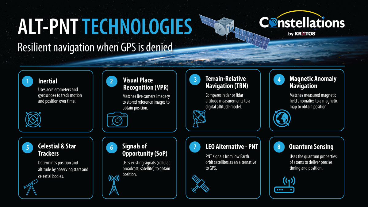
Navigation infrastructure that has relied for decades on GPS is facing a structural reassessment as electronic warfare, commercial innovation and procurement gaps intersect.
A recent analysis from the Harvard Kennedy School Belfer Center concluded that several non-GPS navigation methods are now mature enough for operational use, but the United States has not yet organized them into a coherent national architecture. The study also noted that commercial providers are advancing new frequency bands, orbital regimes and timing methods that government programs have been slow to incorporate.
Across defense, aviation, logistics and autonomous systems, diversification efforts are gaining momentum. The question shaping these developments is whether a broader mix of signals and sensing methods can produce a more resilient navigation environment than the uniform satellite model that has dominated for the past thirty years.
Growing Pressure on a Uniform Architecture
Today’s navigation environment is already more diverse than reliance on GPS alone would suggest. China, Europe and Russia operate global systems, while Japan and India operate regional systems. More than 96% of receivers and devices on the market incorporate signals from multiple constellations transmitting on multiple frequencies, Lisa Dyer, executive director at GPS Innovation Alliance (GPSIA), told Constellations.
That expands the available signals, but differences in ownership do not necessarily provide equally substantial differences in technical vulnerability. Much of the established global navigation satellite system (GNSS) infrastructure shares the same basic orbital and spectral characteristics, Patrick Shannon, founder and CEO of TrustPoint, told Constellations.
“For the most part, all current GNSS services operate from the same orbits and at the same frequencies: medium Earth orbit, and the L-band frequencies we’ve all been using for decades from GPS and its international counterparts,” Shannon said.
More than 200 L-band GNSS satellites are transmitting in orbit, while services using alternative frequencies were scarce when TrustPoint began pursuing C-band. The established model has delivered navigation to an enormous population of users, but its uniformity leaves gaps for applications with different resilience requirements, Shannon said.
“The reality is, we’ve been operating from a perspective of ‘one size fits most,’ and that’s not going to work for resilience,” Shannon said.
“The reality is, we’ve been operating from a perspective of ‘one size fits most,’ and that’s not going to work for resilience.” -Patrick Shannon, TrustPoint
Changing the orbit and frequency creates opportunities to separate new services from existing systems. Security and anti-jam performance also need to be incorporated into their design, Shannon said.
The definition of resilience must account for more than whether a receiver produces a position. Spoofing can leave equipment operating while supplying false information, making confidence in the result a separate operational requirement, Rohit Braggs, vice president of PNT at Iridium, told Constellations.
“Resilience used to mean ‘can I get a fix?’ Today it means ‘Should I believe this fix?’ A spoofed system isn’t down; it’s confidently wrong. The future of resilience is trust and certainty, not just accuracy,” Braggs said.
“Resilience used to mean ‘can I get a fix?’ Today it means ‘Should I believe this fix?’ A spoofed system isn’t down; it’s confidently wrong. The future of resilience is trust and certainty, not just accuracy.” -Rohit Braggs, Iridium
A navigation architecture therefore needs ways to assess its inputs, particularly when sources disagree. An additional signal is most useful as a check when its design avoids the failure mode affecting the information it is checking, Braggs said.
Why GPS Remains a Cornerstone
Despite increased pressure on satellite-based systems, GPS continues to provide extraordinary reliability and economic value. FAA metrics place its availability above 99.99 percent.
“Americans have been incredibly well-served by GPS, to the tune of $1.4 trillion and counting returned to the United States economy,” Dyer said.
“Americans have been incredibly well-served by GPS, to the tune of $1.4 trillion and counting returned to the United States economy.” -Lisa Dyer, GPS Innovation Alliance
Dyer highlighted the efficiencies of a single infrastructure serving multiple domains. “GPS is one of the greatest public-private success stories in history,” she said. She noted that precision targeting reduces munitions requirements, digitally enabled construction minimizes rework at military installations and improved weather forecasting strengthens both operational planning and satellite launch readiness.
She emphasized that GPS delivers significant cost savings while meeting and exceeding military needs. One taxpayer-funded system supports military, civil, commercial and scientific users. Its accuracy lowers acquisition, storage and transport costs by reducing the number of munitions required and helps limit delays and rework through GPS based digital construction. GPS also enhances weather forecasting for operations and launches and plays a critical role in reducing civilian casualties – an invaluable contribution to the United States’ global reputation, she said.
“Weather forecasts used in military operational planning and satellite launches have been improved by GPS,” Dyer said. “And you can’t place a dollar value on the cost of reducing civilian casualties for the United States’ global reputation.”
But modernization is a priority for addressing current threats, Dyer said, noting the imbalance between operational risks and policy timelines. “Jamming and spoofing is a today issue, and our technological and regulatory solutions are timed to tomorrow,” she said.
“Jamming and spoofing is a today issue, and our technological and regulatory solutions are timed to tomorrow.” -Lisa Dyer, GPS Innovation Alliance
GPSIA is calling for a coordinated national effort to confront growing jamming and spoofing threats, starting with an accelerated GPS modernization push, Dyer said.
The newer GPS III and IIIF satellites offer far stronger protection – up to 63 times better – but the nation still needs more of them on orbit, a modern ground station able to manage all military and civil signals, and receivers capable of using the upgraded features, she said.
“And like others, we are watching the future of the launch market because we think prioritizing satellite-based PNT best serves our military and customers of U.S. innovations globally,” Dyer said.
Commercial Architectures Expand the PNT Landscape
Commercial PNT providers are taking different approaches to separating their services from traditional GNSS. Those choices involve trade-offs among spectrum, signal strength, receiver compatibility and the infrastructure needed to deliver the service.
L-band retains practical advantages for satellite navigation. Its propagation characteristics support better penetration through foliage and buildings than higher frequencies, and manufacturers can draw on an extensive ecosystem of proven antennas and receiver components, Braggs said.
Iridium operates in L-band while changing other elements of the architecture. Its PNT service draws on 66 crosslinked low Earth orbit satellites and uses cryptographically secured, one-way bursts offset from GNSS frequencies. User devices receive the service without transmitting, Braggs said.
The signal can reach users at up to 1,000 times the strength of GPS, supporting indoor reception and operation under interference, Braggs said.
But the wider advantage lies in the separation among the sources used to establish a trusted solution, he said.
“Against sophisticated spoofing, what protects you is a source that doesn’t share the failure mode it is checking,” he said.
“Against sophisticated spoofing, what protects you is a source that doesn’t share the failure mode it is checking.” -Rohit Braggs, Iridium
Meanwhile, TrustPoint is pursuing a C-band service in LEO, introducing frequency separation from established L-band constellations.
The company’s design in the 5 GHz C-band leverages a mature commercial component ecosystem while operating in low Earth orbit to deliver higher signal power and stronger Doppler characteristics, Shannon said. “Our signals are five to six orders of magnitude harder to disrupt than traditional L-band GNSS,” he said.
Space-based radio navigation remains attractive because it can combine broad geographic reach with low-power, relatively inexpensive user equipment. Other navigation methods contribute useful capabilities but can impose different size, power and cost requirements on the platform, Shannon said.
The C-band service also draws on investment made in other wireless markets. Existing component suppliers can support receiver development, while the 5010–5030 MHz band already has an international allocation for satellite radionavigation, Shannon said.
Receiver development provides one measure of how quickly a new satellite service can become usable. TrustPoint’s work with Hexagon subsidiary NovAtel recently demonstrated an enhanced receiver acquiring and tracking its signal from space, with testing also covering simulated electronic warfare scenarios, Shannon said.
Other providers are exploring alternative geometries, hybrid ground and satellite architectures and authentication focused signal designs. The Harvard Kennedy School paper noted that while these approaches are operationally credible, they remain largely underutilized at the institutional level.
Quantum Sensing and Non-Satellite Techniques
Advances in quantum sensing and non-satellite navigation have created options that operate outside the radio-frequency spectrum. These methods appeal to operators planning for contested environments by offering internally derived navigation data.
“Atomic clocks are the most mature quantum-sensing technology in practical terms, and chip-scale versions have been commercially available for more than ten years,” Mary Burkey, staff scientist at Lawrence Livermore National Laboratory, told Constellations. Research programs have also advanced optical clocks, quantum magnetometers and gravimeters.
Burkey explained why these methods matter for resilience. “Quantum-sensing approaches reduce GNSS vulnerability by generating PNT information internally or by referencing persistent features of Earth, rather than depending on weak or vulnerable external signals. Thus, these sensors are intrinsically resistant to jamming and spoofing attacks on the external signals they don’t need,” she said.
Quantum inertial sensors can preserve accurate navigation longer after external signals are lost, while quantum magnetometers and gravimeters enable map matching that helps control drift, Burkey said. Classical methods such as celestial and terrain referenced navigation provide additional support but are limited by weather and terrain, she said.
“Hybrid navigation systems will be essential because no single alternate PNT source can match GNSS in every circumstance,” she said.
“Hybrid navigation systems will be essential because no single alternate PNT source can match GNSS in every circumstance.” -Mary Burkey, Lawrence Livermore National Laboratory
A modular, multi source architecture would let vehicles in GNSS denied environments draw on whatever inputs are available to maintain accuracy, reduce satellite dependence, and keep operating, Burkey said.
Establishing Clear Criteria for Resilience
A common definition of resilience is needed before new systems can be evaluated consistently. GPSIA has called for criteria covering diversity of orbits, spectrum and frequencies before governments make allocation and investment decisions, Dyer said.
Those criteria must also distinguish an additional source from an independent one. Before a navigation satellite can provide users with position and time references, it must establish its own position and time. Some systems obtain those references by listening to GPS, Shannon said.
That creates an upstream dependency which may not be apparent from the user signal. A constellation that derives fundamental timing from GPS can inherit its vulnerabilities even if it transmits through a separate service, Shannon said.
TrustPoint is developing a ground segment that supplies its satellites with independent timing and tracking. That infrastructure is intended to allow the constellation to continue functioning when GPS or other L-band GNSS signals are disrupted, Shannon said.
Independence also extends to the engineering and operational processes supporting the service. Authentication, encryption and quality control must be incorporated across user equipment, satellites and the laboratory infrastructure that validates hardware before launch, Shannon said.
Commercial entrants can introduce those design choices without carrying the same compatibility obligations as established constellations. Nearly 8 billion GNSS devices are already in use, constraining changes to legacy signals, while approximately 2 billion new devices produced annually create opportunities for new capabilities to enter the market, Shannon said.
Different ownership and funding models can provide another form of diversity by influencing how systems are developed and operated, Shannon said.
“I think commercial systems and commercial business models are the best way to build out this ecosystem,” Shannon said.
“I think commercial systems and commercial business models are the best way to build out this ecosystem.” -Patrick Shannon, TrustPoint
However, evaluating an emerging system requires examining realistic funding plans, transmission authorization, international coordination and the schedule for ground and monitoring stations, Dyer noted. Evidence of continuity, integrity, accuracy and availability must match the intended use, particularly in public safety applications, Dyer said.
That assessment connects commercial viability with technical independence. A signal users can receive today still needs the infrastructure, operating model and continuity provisions required for the period in which they expect to depend on it, she said.
When asked whether a new system can enhance “resilience,” Dyer considers several questions, including:
- What stage the technology is in – marketing concept, partially developed or fully operational.
- How the system will be funded and whether those plans are realistic.
- Whether the provider has authorization to transmit in the required frequencies and has filed the necessary ITU paperwork.
- Whether data is available to assess the system’s resistance to jamming and spoofing.
- Whether the signals can meet required continuity, integrity, accuracy and availability standards for public safety.
- Whether the system requires ground and monitoring stations, and the timeline for deploying them.
- How the signals could be integrated into more than six billion existing devices, along with transportation and weapons systems.
- What standards must be developed for regulated receivers, such as those used in aviation.
- Whether scientists could rely on the signals for geodetic work, including updates to the National Spatial Reference System.
“You need to think about and design potential sources as a complete, end-to-end, integrated system,” Dyer said.
A Navigation Environment Moving Toward Multiplicity
The converging trajectories of modernization, commercial innovation and emerging non GPS capabilities are pushing the navigation sector toward a more layered architecture akin to what’s already been established in communications.
Fiber, wireless networks and satellite services coexist because users have different requirements, and commercial PNT providers can develop a similarly varied portfolio of capabilities, Shannon said.
“There are just many ways to move data from one place to another today. We don’t have that in PNT,” Shannon said.
“We are strongly in favor of multi-band and hybrid architectures. The frontier isn’t simply more satellites. It’s fusion at the edge,” Braggs said, echoing Shannon.
He said this shift points toward receivers that fuse multiple inputs – such as multi band GNSS, inertial sensors and independent satellite or terrestrial signals – to validate one another rather than rely on a single source. Systems using this approach are already in development. Demonstrations under live jamming and spoofing have illustrated how an independent signal, such as Iridium’s, can serve as an independent cross-check to determine whether the system’s outputs can be trusted, Braggs said.
Looking Forward
PNT diversification is advancing through a mix of satellite alternatives, terrestrial signals, quantum sensors and environmental references as institutions work to develop the policies, standards and acquisition frameworks needed to bring those technologies into operational use.
The next decade of navigation systems will test whether expanding technical choice produces infrastructure that users can actually depend on. The standards manufacturers adopt, the performance governments purchase and the independent systems providers sustain will determine how much of that choice remains available when the primary source fails.
For GPSIA, the national architecture would retain a fully modernized GPS at its core, supported by complementary commercial systems. Delivering it requires coordination across satellites, ground stations, receivers, spectrum authorization, standards and launch availability, Dyer said.
The leadership challenge is to keep those efforts directed toward a shared objective across government, regulators, industry and Congress, Dyer said.
“I’d like to see the United States leading the world in PNT systems, with cutting edge satellite, ground station, and receiver and device technologies available to military, civil, commercial and scientific users,” Dyer said.